
Apple Maps Expands 3D Street View Feature to Boston, Philadelphia, and Washington, D.C. - MacRumorsOpen MenuShow RoundupsShow Forums menuVisit ForumsOpen Sidebar
Skip to Content

Apple Maps Expands 3D Street View Feature to Boston, Philadelphia, and Washington, D.C.

As noted in the MacRumors forums, the new Look Around feature in Apple Maps recently went live in three more cities in the United States, including Boston, Philadelphia, and the Washington, D.C. area.

Introduced in iOS 13, Look Around is an interactive way to visually explore a city with 3D street-level imagery, similar to Google Street View. The feature is also available in the San Francisco Bay Area, Los Angeles, New York City, Las Vegas, Houston, and the Hawaiian island of Oahu, with many more places to come.
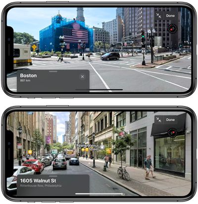
apple maps look around philadelphia boston
In an area where Look Around is available, a binoculars icon will appear in the top-right corner of Apple Maps. Tapping that icon opens a street-level view in a card overlay at the top of the screen. Look Around also appears in the search results for a supported city, below the Flyover and Directions buttons.

When you're in Look Around mode, tapping on the display lets you move through the area, while tapping in a far off spot in the distance zooms in quickly in a smoother and more immersive way than Google Street View.

To help orient you in Look Around mode, points of interest such as bars, restaurants, parks and the like are identified by floating icons at street level. Note, however, that you can only zoom into areas that can be accessed by vehicles since the Look Around data is captured by cars fitted with 360-degree cameras.

Related: How to Use Look Around in Apple Maps
Popular Stories

trump lake america

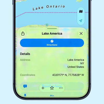
Apple Maps Renames Lake Ontario 'Lake America'

Tuesday September 1, 2026 1:58 pm PDT by
Apple Maps users in the United States will now see "Lake America" instead of "Lake Ontario" for the Great Lake on the border of Ontario and New York. The updated name is currently rolling out to iPhone, iPad, and Mac users. The Maps app still has the Lake Ontario label for the body of water, but tapping it now says "Lake America." Apple will likely change the label in the next few hours....
Apple Maps Google Maps Icons

Google Maps Showing 'Lake America' in U.S., Apple Maps Yet to Follow

Monday August 31, 2026 6:33 am PDT by
Google Maps users in the U.S. will now see the name "Lake America" instead of "Lake Ontario" for the Great Lake that straddles the New York—Ontario border. Google said it made this change in response to the U.S. Geographic Names Information System (GNIS) updating the name for "Lake Ontario" to "Lake America," following an executive order issued by U.S. President Donald Trump last week....
apple maps ads live

Apple Maps Ads Are Here, and There's No Way to Turn Them Off

Tuesday August 25, 2026 1:40 pm PDT by
Ads in Apple Maps are live in the United States and Canada, which means iPhone and iPad users will see them when searching for locations and when viewing Suggested Places. Apple announced plans to bring ads to the Maps app in March, and said the feature would roll out starting in late summer. Apple confirmed to 9to5Mac that ads began showing up for users over the last few days, with ad...

Top Rated Comments

CarlJ Avatar
86 months ago

Great quality. Much better than most of current Google Street View images. Funny thing that Google launched Street View in 2007. It took Apple 12 years to come up with something similar.
Uh, 12 years ago Apple wasn't in the mapping business.

How good were you at, say, reading or math, 5 years before you were born?
Score: 13 Votes (Like | Disagree)
86 months ago

Great quality. Much better than most of current Google Street View images. Funny thing that Google launched Street View in 2007. It took Apple 12 years to come up with something similar.
In 2007, Apple was busy unveiling a transformative device that changed the way we live, all the while protecting our privacy.

Some might say Google has yet to come up with something similar. 😁
Score: 6 Votes (Like | Disagree)
r3econ Avatar
86 months ago
Great quality. Much better than most of current Google Street View images. Funny thing that Google launched Street View in 2007. It took Apple 12 years to come up with something similar.
Score: 6 Votes (Like | Disagree)
bchery21 Avatar
86 months ago
With a radius that covers all the way out to Waltham it seems, nice!
Score: 4 Votes (Like | Disagree)
cmaier Avatar
86 months ago

This is a fantastic new feature. Have to say I am disappointed that Apple is playing out the cliché by starting on both coasts and abandoning the middle of the country.
It‘s a practical decision - that’s where the population is higher. Get the feature to more people sooner that way. They’ll get the rest of the country before too long.
Score: 3 Votes (Like | Disagree)
86 months ago

Great quality. Much better than most of current Google Street View images. Funny thing that Google launched Street View in 2007. It took Apple 12 years to come up with something similar.
I suspect that has to do with Google and Apple's different business models. Google developed maps as a means to collect huge amounts of user data that could be used to sell ads, their core business, and thus was highly incentivized to get the ball rolling.
Score: 3 Votes (Like | Disagree)

🔗 Related Apple News & Rumors

Stay updated with the latest Apple ecosystem news and verified rumors