

Apple Maps Vehicles Begin Surveying Canada - MacRumorsOpen MenuShow RoundupsShow Forums menuVisit ForumsOpen Sidebar
Skip to Content

Apple Maps Vehicles Begin Surveying Canada

Apple today announced that its Apple Maps vehicles are now surveying Canada for the first time over the summer months.
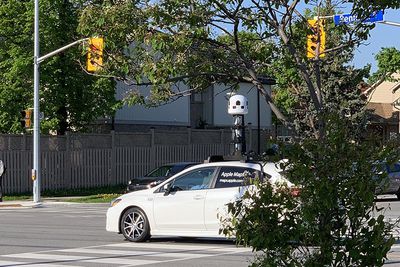
apple car toronto

‌Apple Maps‌ vehicle on Renforth Drive in Toronto via Reddit user whatifyoutry

The vehicles will drive across all 10 provinces between May and November, including British Columbia, Alberta, Saskatchewan, Manitoba, Ontario, Québec, New Brunswick, Nova Scotia, Newfoundland and Labrador, and Prince Edward Island. The vehicles have already been spotted in the Toronto area.

Absent from Apple's list are the northern territories of Yukon, Northwest Territories, and Nunavut, which are sparsely populated.

The data collected, including the likes of road details, signage, and landmarks, will be used to improve ‌Apple Maps‌ as part of Apple's efforts to rebuild the service, which began in the United States.
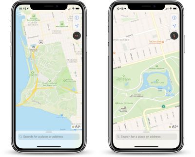
ios12newmapssf

‌Apple Maps‌ with more detailed data in Northern California

Apple's full statement:

Beginning in May, Apple Maps will be driving across Canada throughout the summer. We'll be capturing road details, signage and landmarks — all to make the most accurate and useful Maps experience possible. The information collected will be worked on by our teams in Cupertino, California. We plan to publish this data in a future product update.

We always have your privacy in mind, so we're working closely with local regulators to ensure we follow all laws and regulations. All of our vehicles are marked Apple Maps, so you'll always know it's us.

Privacy is a fundamental Apple principle, so we're proud to build it into everything we do.

‌Apple Maps‌ vehicles have also surveyed parts of the United States, United Kingdom, Ireland, Italy, France, Spain, Sweden, Slovenia, Portugal, Croatia, Japan, Andorra, and Puerto Rico since data collection began in 2015.

Beyond improvements to ‌Apple Maps‌, it has long been speculated that the data collected could benefit Apple's development of self-driving technologies or pave the way for Apple to launch its own Street View, but there is no concrete evidence at this point to suggest that either of those possibilities are true.
Popular Stories

Ads Are Coming to Apple Maps Feature

Apple Won't Allow These Ad Categories in the Maps App

Wednesday July 15, 2026 2:01 pm PDT by
Apple this week shared a new Advertising Services policy outlining the kinds of ads that won't be allowed in the Maps app. As noted by TechCrunch, Apple has a list of ad categories that are not permitted in Apple Maps. Home services - Ads that directly or indirectly promote home services are not allowed. That includes but is not limited to plumbing, electrical, locksmith, HVAC, pest...
Apple Maps General

Apple Maps to Help Power Autonomous Driving in Ford's 2027 EV

Thursday July 23, 2026 6:27 am PDT by
Apple and Ford today announced announced that Apple Maps will power the navigation system in Ford's upcoming Universal Electric Vehicle (UEV) Platform, launching in 2027 at a price point around $30,000. The integration leverages Apple's new MapKit for Automotive SDK, allowing Ford to embed Apple Maps directly into the vehicle's displays while maintaining the ability to customize the...
Apple Event Logo

Apple Working on All-New Operating System

Wednesday July 29, 2026 11:39 am PDT by
Apple is developing an all-new operating system that is essentially a mix of tvOS, watchOS, and iOS, according to Bloomberg's Mark Gurman. In a report this week, he said the operating system will feature a grid of icons, widgets, and apps, along with customizable clock faces. The new software platform is intended for Apple's long-rumored smart home hub. With built-in facial recognition,...

Top Rated Comments

sfobear Avatar
94 months ago
WTH! I just pulled up Apple Craps (err, I mean Maps) on my MBP that is hardwired with an ethernet connection. I clicked on the Show You Current Locate button and got the following message box stating I needed to turn on WiFi. Seriously! Does Apple not know that ethernet can also give me an internet connection? Are their developers really that stupid these days? Apparently so! and yes the ethernet connection was providing 200 Mbits solid connection at the time... :confused:

Before you get carried away calling too many developers stupid, it's how the geolocation on our various devices is designed to work. Here's an article that might help you:

https://www.lifewire.com/wifi-positioning-system-1683343

So it's not just about having an internet connection...
Score: 14 Votes (Like | Disagree)
94 months ago
Good, now just a few more countries to go. Should be done by 2095.
Score: 13 Votes (Like | Disagree)
JimmyBanks6 Avatar
94 months ago
I still don't understand why there isn't a web based Apple Maps.

They would be able to acquire so much more data if Apple Maps results were available on a browser, instead, you have to use an iOS device, which to me is a draconian requirement.
Score: 9 Votes (Like | Disagree)
A MacBook lover Avatar
94 months ago
C3 technologies scanned Street, Ariel (and pedestrian level?? ('https://images.app.goo.gl/QVwKWrMt7PZmY64E9')) 3D MAPS, Apple has been building for years.

They may have set up the best foundation for autonomous driving yet.

Maps app itself is getting pretty great. In my situation, just adding speed traps and such would make me switch fully from Waze. I don’t even use google maps anymore.
Score: 7 Votes (Like | Disagree)
JimmyBanks6 Avatar
94 months ago
Why is it ‘better’? I used to think this too....like three-ish years ago. Apple Maps has matured nicely over the years more hot to date roadways/Closures/Siri is more pronounced, actually to the point, where I deleted Google Maps, And Apple Maps is the only source I need.
- Does Apple Maps have street view? Isn't appearing on my phone right now.
- Google Maps 3D is significantly better than Apple Maps. Apple Maps only focuses on major cities, while Google seems to have used satellites to hit everywhere in the world. I live in a small town and all buildings are 3D.
- No offline maps - [edit] apparently this is wrong, which is good to know.
Score: 5 Votes (Like | Disagree)
Glockworkorange Avatar
94 months ago
C3 technologies scanned Street, Ariel (and pedestrian level?? ('https://images.app.goo.gl/QVwKWrMt7PZmY64E9')) 3D MAPS, Apple has been building for years.

They may have set up the best foundation for autonomous driving yet.

Maps app itself is getting pretty great. In my situation, just adding speed traps and such would make me switch fully from Waze. I don’t even use google maps anymore.
I already use Apple Maps exclusively. The CarPlay, Siri and Watch integration without good enough directions are all I need.

Nice to see people up north getting the same treatment. They've come along way since 2012; they really should've announced the product in beta.
Score: 5 Votes (Like | Disagree)

🔗 Related Apple News & Rumors

Stay updated with the latest Apple ecosystem news and verified rumors